My regular riding buddy Pat Bianchi gave me a heads up on another BMW club run, this time they were headed to the little seaside community of Morro Bay up by the top of the lower third of the California state coast.
Pat had reserved a room and asked if I like to join him and the club again for this run. The weather was shaping up to be perfect spring California weather so I said why not......seemed like a good reason to hit the road again (lol...and I certainly don't need to much prodding in this direction)
After the initial run with the club to Kernville the month before I knew what to expect this time out...... beautiful California scenery, some roads I probably had never been on before and a pleasurable ride with a group of people that have a passion for motorcycling.......And I sure wasn't disappointed!
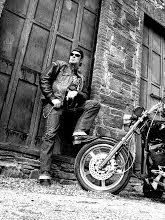
Pat and I got up early Saturday morning and rode out west on the 101 Freeway to Newberry Park to meet the BMW group at the local BMW motorcycle dealership

After a brief orientation and some discussion of the day's route the group fired up their motorbikes and we all headed out.
Like I said before the really cool thing that some of the members of the BMW club do is map out a wonderful route entirely consisting of back roads and highways.
As we made our way to Highway 126 the first little town we encountered was Santa Paula

After riding through Santa Paula we ventured west on Highway 150 moving on into the Ojai valley......the ride along the 150 is quite pleasant as you ride past wooded Oak hills and the various types of farms and ranches
Here we had to wait as the road became only lane after the road was partially washed out during the winter

Pretty cool 1950's corvette in line with us here

The Ojai valley was home to the Chumash Indians before becoming one of many Spanish land grants along the California coast.

Our first rest stop was at a little pizza parlor called Boccali's as we came into the Ojai valley

I kinda liked this shot......one for the girlies.....nothing says I love you like roses and a Budweiser...lol

The city originally was called Nordhoff but because of anti German sentiment during world war one the city was renamed Ojai, it's a Chumash Indian word meaning "Valley of the Moon"
After fire destroyed much of the original western-style buildings in 1917, Edward Drummond Libbey, the early owner of the Libbey Glass Company helped design, finance and build a new downtown more in line with the contemporary taste for Colonial-Revival architecture, including a Spanish-style arcade, a bell-tower reminiscent of the famous campanile in Havana, and a pergola opposite the arcade. These buildings still stand, and have come to serve as symbols of the city and the surrounding valley
The town of Ojai and its surrounding area is home to many unique recreational activities. The Los Padres National Forest borders the town on the north, and many back country areas within the forest are accessible from Highway 33, which is the major highway through town south to north.
We took Highway 33 to the North and into the Los Padres National Forest

As we crested the top of the mountains the view below was spectacular

The group by this time was a bit spread out and we were all supposed to meet at the ranger station located at the base of the mountain to re-group.
I spoke to Bruce the ride leader and asked if I could ride ahead while they were waiting for the rest of the riders to show up, I knew that up the road was my favorite place to buy the local pistachios whose farms are dotted all along this section of Highway 33, he said sure go ahead we'll catch up with you down the road
Well besides being able to get my pistachio fix I was able to stop here and there along the road and take a few photos of things I found of interest,
Like this old shack......abandoned and nobody home

Or the desert roadside icon, an old rusted truck that seems to always be somewhere along the Highway slowly corroding under a mid-day's sun and the changing seasons

And of course you can also always find some abandoned closed up juke joint
that no longer serves up a cold one......Like this place called the Sagebrush

I arrived at the Santa Barbara pistachio store and cafe and picked up a couple of bags of my favorite chili and lemon flavored pistachio's

Pat rolled up and said the group was right behind so we both got back on the road and fell right in with everyone

Heading East on Highway 33 towards the city of Taft we passed this old gas station minus the gas pumps

This area along the 33 is all flat with some rolling hills but mostly dry and brown this time of year

The city of Taft is nestled in the foothills at the extreme southwestern edge of the San Joaquin Valley, just 35 minutes from Bakersfield, two hours from Los Angeles, and two hours from California's Central Coast.
Taft is situated in a major petroleum and natural gas production region in California and is one of the few remaining towns in the United States which exist exclusively because of nearby oil reserves. The discovery of oil in the region occurred in the late 1800s near Maricopa, seven miles (11 km) south of Taft.
This little desert town has been around sense 1900 and these days besides the oil business it's also known as the place that skydivers like to take off from and jump out over the desert landscape.
We all stopped in town for lunch at Jo's restaurant which had a lot of old Oil company memorabilia on the walls along with friendly service and decent food

I told Pat to get us a table and I would be back later because I wanted to make a quick loop around the town and take some pictures, having a sign fetish I wasn't disappointed in what I found around this small desert town

Here's a great old neon sign for the Oil, Chemical, and Atomic Workers International Union

Or this great old art deco 1930's Fox theater sign

How about Koontz Appliances, still advertising a pot belly stove on the storefront

I liked this old Coca-Cola sign on the side of this brick building

Or this great old neon sign for the Oasis bar and restaurant

Of course most of these old towns in America always have some sort of Masonic Lodge,
here is the International Order of Odd Fellows building

I liked this doorway on an old Quonset hut with the corrugated sides flaking what's left of it's paint

Stopping at the edge of town I came across this cool 1950's Topper motel sign

So after a nice lunch we all gassed up and continued onward past the oil fields and cattle ranches that sit along the highway


I like riding the desert highway's, it's always been a place of great mystery
and it's in these times of looking out across the desolate landscapes that one tends to go inward with ones thoughts............. and then, as you pass something along the road you wonder what someone's dreams might have been when they built this structure that is now just a rotting abandoned shack waiting to collapse from the elements.....

As we gradually started climbing from the desert floor to rolling hills, the vegetation started to become less sparse as we got on Highway 58 now moving west again


From Highway 58 we kept going west onto Highway 229 through the mountains for a bit and then connected onto Highway 41 which would take us all the way into Morro Bay


Arriving at our motel was a welcome site as the day's ride was starting to wear on my bootie more than I'd like to admit, so it was good to get off the bike, unpack and rest a bit

We all stayed at the Tradewinds Motel which just happened to be one block up from the wharf, Pat feeling tired decided to take a nap before dinner and I decided to go for a walk and take some photos.

The town of Morro Bay was founded by Franklin Riley in 1870 as a port for the export of dairy and ranch products. He was instrumental in the building of a wharf which has now become the Embarcadero. During the 1870s, schooners could often be seen at the Embarcadero picking up wool, potatoes, barley, and dairy products.

In the 1940s, Morro Bay developed an abalone fishing industry. Having peaked in 1957, stocks of abalone have now declined significantly due to overfishing, it still remains a fishing port for halibut, sole, rockfish, albacore, and many other species for both commercial and sport vessels.


The town now has been a center for beach holidays, tourism is the city's largest industry and the most popular beach is on the north side of Morro Rock, north of the harbor in fact I used to trailer my horses up to this state park called Montaña De Oro and run them on the beach (it was great fun) and if you'd ever go there it's a wonderful place to camp
Moving along the wharf I spotted a lot of old fishing boats, various birds and generally people just having nice afternoon as the sun was starting to ride low in the sky


Here is the ferry where you can take a local scenic cruse

Another point of interest that you can't miss in Morro Bay is the Dynegy power plant built in the 1950's and it's tall 450 foot stacks, they are quite impressive to see up close

The coast guard station was established here in 1948

Here is a great old 1953 Pontiac station wagon I found parked in front of an art gallery


Walking on I came across a really unique store called the Shell Shop

This amazing shop was opened in 1955 and is still going strong
You can find just about anything to do with sea shells at this place
Walking back to the motel I spotted this cool old metal weather vane

After getting cleaned up from the day's activities it was time to meet everyone at the Harbor Hut restaurant that sits right on the wharf, as everyone settled in for their meal I looked out the large picture window and noticed that the light was right for a few last pic's as the sun was setting


A lone bird sits atop the Morro Bay wharf sign as the sun sets in the western skyline

After a good nights sleep Pat and I got up and headed over to the coffee pot restaurant

While Pat had breakfast I had my vitamins and coffee and walked around the wharf snapping a few more pic's

Here are the Sea Lions that the night before we're barking like crazy,
lol they seem like some of us after a real long night of partying

The other unmistakable thing you'll see in Morro Bay is the Morro Rock which is a large extinct volcano located a few hundred feet off the shore of Morro Bay, It stands 576 feet tall at the entrance to the Morro Bay Harbor and a causeway connects it with the shore. The area around the base of Morro Rock can be visited so it's another thing to see and do if you find yourself in Morro Bay

Pat and I decided to take our own route back to Los Angeles, here is Pat mapping it out while we gassed up the bikes

Heading south on Highway 101 is a picturesque drive for anyone, you'll see a lot of the California coast and coastal landscapes along with the various seaside communities....... Here is the renowned Madonna Inn located in San Luis Obispo,
a great place to stay and it's been here sense 1958..... I loved the really cool old neon sign they have

Moving southward on the 101 you can view the green rolling hills dotted with large oak trees and in this case a herd of horses grazing

In the town of Santa Maria Pat and I headed east on Highway 166 and here you will encounter another great scenic California Highway.
This stretch follows the Cuyama River through a canyon separating the Sierra Madre Mountains from mountains in San Luis Obispo County, and then opens out into the Cuyama Valley, passing cattle ranches, going through the Russell Ranch Oil Field, and passing Aliso Canyon Road, the turnoff to the South Cuyama Oil Field. On the north during this stretch is the mile-high Caliente Range, which contains Caliente Mountain, the highest peak in San Luis Obispo County.


Gassing up in Maricopa I spotted a couple of old neon signs


Pat and I headed back up the 166 to Pine Mountain taking Forest Highway 95 through the mountains of this high desert forest

The first part of the route is rather sparse as you climb and all of this area is a nature preserve for the giant California Condor
As you come into Pine Mountain and the Frasier Park area the topography is much more wooded

Heading now onto Interstate 5 we were on out final leg of our journey

As Pat and I finally rode into Hollywood and Sunset Blvd. we passed a few of the local landmarks...... Here is the famous Whiskey a Go Go

lol....nothing like being in the local traffic again after all those open roads

But that's why you ride I suppose, it's like finding the crease or the seam of life I think..... the route less traveled and the adventure of the open highway,
It's always a journey I love to take
~M
Sniff ...my heart is broken......the last road trip looks amazing! . It's really easy to immerse myself in all those places unknown to me as I just travel through your eyes ...as well you have a way with words ;) . I clearly put Morro bay on my list of places to go.
ReplyDeleteI'm sure it was a hard graft so thank you for taking you time to do that !
(the chili and lemon flavored pistachio's seem to be too tempting to refuse )
Thanks again Ari, your very kind and I appreciate the comment......lol yes the pistachios are hard to refuse and I didn't ;-)
ReplyDeleteI always loved Morro Bay and the Butterfly grove area. But my favorite breakfast joint was Toasties! I forget what the rock looked like on a clear day, it was usually foggy when i went.
ReplyDeletenice pictures!
ReplyDeleteThis was such a wonderful place to visit and indeed, many tourists want to go to this beautiful town. Every place looked so classic and elegant and even the different signs have a creative look and have a good quality government steel strapping and stainless steel banding strap that's why they stay in place.
ReplyDelete